Highway Construction: Undermining Transit Iniatives

All Photos From Google Earth
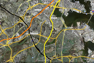
Here we are paying upwards of $3.50 per gallon of gas with it projected to hit $4.00 per gallon in the summer and here we are continuing to commute by car in record numbers and highway construction will only add more cars, more traffic and ultimately more traffic jams which decreases gas mileage and wastes still more gas making the greedy oil companies raise the price of gas even higher. There has been a movement to use public transportation in the Baltimore area but the transit system is lack luster at best and will continue to be so until at least 2035. What will it take to ear mark highway construction funds to pay for transit instead? $10 per gallon? It's not that far fetched.


Most of the highway construction funds are to be used around Baltimore City rather than it which further encourages suburban sprawl. There has also been a recent movement to move back into cities especially young single adults and empty nesters. They, along with college students are the most likely to use transit. The worst part of it is every highway construction project takes away the likelihood of transit lines being built. Don't believe me? Well here's a list of construction projects in and around Baltimore that will take away funds and ridership for transit lines.

$1 Billion+ I-95 Travel Lanes/I-695 interchange Green and Purple Lines

I-695 southwest side widening Orange and Yellow Lines

I-170 Red Line

Boston Street Widening Red Line

Orleans Street Widening Green Line

Northern Parkway/JFX Interchange Improvements Blue Line and Charles St. Trolley Line

I-795 Expansion into Carroll County Green Line Expansion into Carroll County. Although I-795 would go north to Hampstead and the Green Line would go to Westminster you can't fund them both. The Green Line hasn't been extended to I-795's northern Terminus.

White Marsh Boulevard Extension Green and Purple Lines

MLK Boulevard/JFX Interchange Blue and Green Lines

I-70/I-695 Interchange Improvements Red Line

Pratt Street Two Way Conversion Red, Yellow, Green, Blue, and Charles St. Trolley Line

BW Parkway/Russell Street Widening and Reconstruction Blue Yellow and Orange Lines

Dolfield Boulevard/I795 Interchange Green Line

Reisterstown Road/Owings Mills Boulevard Interchange Green Line

A Cherry Hill Divided Will Not Stand

My Own Pictures are Coming Soon
Photo From Developer Website
It was honest Abe some 145 odd years ago who said "A House Divided Will Not Stand." This was during the Civil War years that President Lincoln made this speech but the words still apply today in Baltimore and the entire country. Right now I will apply it to Cherry Hill which may be on the forefront if its own civil war.

Photo From Cherry Hill Master Plan

Cherry Hill differs from other Baltimore in that its history is rather short.The Bulk it was a product of FDRs' "New Deal" to stimulate the economy during the great depression. It was meant to be housing for black World War II veterans returning home. Uplands was its white counterpart. Cherry Hill was built in a time where housing segregation was still the norm. It was one of the last pieces of undeveloped waterfront land in Baltimore located between Westport and Brooklyn it contained some industrial land. After living the life of housing for Veterans the 600 unit Cherry Hill Homes became public housing. Cherry Hill Homes kept expanding over the years topping out at 1713 units. Obviously, Cherry Hill Homes was and is the dominant development creating huge pockets of poverty.

Photo From Baltimore Housing.org
Cherry Hill didn't enjoy a long period of success as a thriving neighborhood. Crime, drugs, vacancies, population loss, and public health concerns over toke the quality life in Cherry Hill. Cherry Hill Homes began a "modernization" process in the 1990s which included the demolition of 193 units bringing the new total of units to 1520. Some new affordable home ownership town homes were built but for the most part, the land that the public housing units remained vacant. Quality of life in Cherry Hill remained low in Cherry Hill despite the notable success of a few residents, the revitalization of Cherry Hill Town Center, 2 aquatic centers, Cherry Hill Park, Middle Branch Park, Reedbird Park, a youth recreation center, a light rail stop, a branch of an Enoch Pratt Library, and 2 medical centers in addition to Harbor Hospital. Cherry Hill might have the most amenities of any neighborhood in Baltimore. In late 2006 an additional 126 units of Cherry Hill Homes were demolished bringing the grand total down to 1394.

Photo From Cherry Master Plan

Today Cherry Hill is a divided community. There is a market push to develop land as upscale apartments, condos, retail, offices, and possibly a boutique hotel seeing as it is a waterfront community. However, crime, gangs, drugs, still persist at disturbing levels. There have been 12 murders in Cherry Hill in the past year. Still the push is on for market rate housing; Waterview Overlook, a brand new upscale town house/condo development is being built in Cherry Hill and it sold out before they laid the first brick! There is also a waiting list in case people change their mind!

Photo From Cherry Hill Master Plan
The perfect analogy for the divided Cherry Hill would be the former Arnett J. Brown Jr. Middle School building. It is now home to two high schools New Era Academy and Southside Academy. New Era Academy is the perfect name for the school too because it represents the soon to be influx of new residents a "new era" if you will. New Era Academy also draws citywide and is for college bound students. In sharp contrast Southside Acdemy students are more local and are much more troubled than their fellow New Era tenants. This has erupted in violence between the two schools in at least one instance the schools were put on lock down.

Photo From Developer Website

Now here comes the tricky part; unifying the divided Cherry Hill. Ok lets start with the buildable parcels of land already available. Waterview Overlook is already being built so we can omit that. There is the industrial land next to the light rail station, there is the wooded undeveloped land next to the light rail station, there is the industrial land between Westport and Cherry Hill and finally there is the vacant land left over from the 319 units of Cherry Hill Homes that were demolished in the 1990s and 2006. To deal with the deep concentration of poverty in Cherry Hill I propose using both conventional and unconventional methods. The conventional method would be more demolition in Cherry Hill Homes, 697 units to be exact which is half of the current 1394. Now I'm projecting about 250 of those 697 units are vacant so the number of displaced families isn't as alarming as one would originally think. The demolished units would be redeveloped as mixed use mixed income housing, retail, and offices.

Photo From Cherry Hill Master Plan

Now the unconventional method; the units preserved in Cherry Hill Homes will be the original 600 (or however many of them are still standing) built before World War II. There has been an interest in reusing pre war public housing as market rate housing, something Baltimore hasn't done so I'm proposing that this be done with the oldest Cherry Hill Homes units however many of them are still standing. They were modernized in semi recent years so they would in fact be "de modernized" to restore them to their original appearance to qualify for historic designation. Now where would the remaining 697 families from the old Cherry Hill Homes Go? The only remaining units will be sold as market rate condos! Well they will be in scattered sites throughout Cherry Hill which will now be solely new homes, offices, and businesses.

Photo From Cherry Hill Master Plan

When President Lincoln said "A House Divided Will Not Stand" could he have been thinking of Cherry Hill?

Reservoir Hill:Could We Be Sitting on Real Estate Gold?

Reservoir Hill or Lake Drive as it was originally called was once considered a suburb to Downtown Baltimore and was home to Eastern European Jews who made it big. It also was and still is to some extent home to some of Baltimore's best row house architecture. Its proximity to Druid Hill Park and Eutaw Place (Bolton Hill) made a destination from the cramped over crowded neighborhoods of Old East Baltimore where the poorer Jews were still living. In addition to row houses some Reservoir Hill residents fancied the luxury of apartment living. Like the row houses, apartment buildings were also architectural gems. Although Reservoir Hill was an upscale neighborhood in its own right, it always played second fiddle to its neighbor to the south; Bolton Hill.
The story of Reservoir Hill after World War II is one that I've told many on this blog in different variations but I keep telling it because it has so much significance in Baltimore and urban America as a whole. Since the homes in Reservoir Hill are so large in size many divided into apartments to deal with over crowding. Since it wasn't too far from the black neighborhoods Reservoir Hill became majority black almost overnight. There was little to no evidence of block busting tactics here but I'm sure it was used by block busters as an example of how fast a neighborhood could change.
The flight to the suburbs was on in full force in the 1960s and 70s. It seemed as though urban America had become nothing but slums for the poor. Reservoir Hill had become one of those places with a sizable chunk of its housig stock being devoted to low income families. It was at this that Lakeview Towers and Extension was built. These were two public housing high rises located between Reservoir Hill and Druid Hill Park. Speaking of Druid Hill Park, it had been completely sealed off on all sides by high speed parkways and interstates. By the 1980s the blows of being an inner city neighborhood had taken their toll on Reservoir Hill. Population loss, trash in the streets, vacant boarded up homes, and a high crime rate had taken over this once grand upscale neighborhood.
Today Reservoir Hill is in transition. Revitalization efforts have come in fits and spurts with varying levels of success. Homesteaders have lovingly restored blighted houses to their original elegance making homes that were multi family single family once again. The real esate boom of the early 2000s have made prices in Reservoir Hill shoot up sky high only to have that back fire by the real estate slump we're currently in. One reason Reservoir Hill hasn't gentrified the way citizens and elected officials have hoped is because it was done backwards. Usually a big development or redevelopment project will occur first and then spur homesteaders. Another reason is because so much of Reservoir Hill's housing stock is federally subsidized and it has to stay that way for a certain number of years, a roadblock for a mixed income community. There has however been news on the development front for Reservoir Hill.
Vistas on the Lake" a new condo development taking advantage of the views of Druid Hill Park is being proposed by the same developer of "Waterview Overlook" in Cherry Hill. Remember when I talked about how grand it was to have an apartment in Reservoir Hill? Well I'd like to recapture that in a couple ways first demolishing Lakeview Towers and Extension and redeveloping it as a mixed use mixed income community. Second I will take the old once grand apartment buildings and rehab them into upscale condos and/or apartments complete with valet services, concierge, doorman, business center, and 24 hour on site maintenance. With big developments projects I'm proposing in addition to the already proposed "Vistas on the Lake" row house homesteading will be much more successful. Another problem with Reservoir Hill is its accessibility to its neighbors Druid Hill Park and Bolton Hill. Druid Park Lake Drive current separates Reservoir Hill from Druid Hill Park and is currently 10 lanes. I would have it narrowed down to 4 lanes to create room for a sidewalk and a lane designed for bikes. I would narrow North Avenue which separates Reservoir Hill from Bolton Hill and rebuild the homes destroyed to widen it further integrating the two neighborhoods together. Lastly I would widen Eutaw Place in reservoir Hill to expand the beautiful green landscaped median in Bolton Hill and turn it to two way traffic.
Now the initial question I posed was: Reservoir Hill Could We Be Sitting on Real Estate Gold? Short Answer Yes and you just read the long one.

Waverly: Still Yellow After All These Years

Yellow, in traffic it means slow down, prepare to stop or use caution conditions ahead maybe be hazardous. The cluster of neighborhoods I will describe all will focus on the same theme: the color yellow and the traffic signal analogy.
The title of the post can be deceiving it says they're waiting to turn yellow but they already are. The current conditions for someone who lives there or is visiting would have to use caution as there maybe hazardous conditions ahead. Waverly lies east of Greenmount Avenue north of Downtown and are a mix of row houses, lack luster retail, blighted industrial uses, surface parking lots and vacant under utilized land.
The color yellow wasn't always so closely associated with the greater Waverly area. It used to be "Green" as in all systems go full speed ahead. The communities grew as farming villages along the York Road just north of the city line. Rich businessmen built their weekend and summer estates along here as well. In the mid to late 1800s the greater Waverly area was annexed by the city and the neighborhoods were developed with row house and light industry throughout. By the mid 20th century the color yellow was being introduced into the cluster of neighborhoods. Overcrowding, blight, and white flight in East Baltimore Midway was occurring. Rather than turning "red" and turning the neighborhoods into crime infested ghettos by building public housing high rises the city did something a little different.
They rehabbed targeted blocks mostly along Grennmount Avenue and other main neighborhood streets and located the new Stadium for the Orioles on 33rd just east of Waverly in the Ednor Gardens neighborhood dubbed "Memorial Stadium." Memorial Stadium was a great boost to the neighborhoods surrounding it making them "Green" as in full speed ahead all systems go. East Baltimore Midway was still struggling but everything else was in good shape. Waverly and Ednor Gardens had become one of Baltimore's most culturally and economically diverse neighborhoods at a time when that wasn't the norm. Memorial Stadium carried Wavelry and Ednor Gardens into the 1980s when decline finally set in the neighborhoods began to turn "Yellow". Population loss and vacant boarded up houses were showing up. Even Memorial Stadium, the area's driving force was beginning to age and with the Inner Harbor revitalization its location seemed out of the way. The 1991 baseball season was the Os last at Memorial Stadium and next year they moved into their brand new home dubbed "Oriole Park at Camden Yards" which became a model for building new stadiums. It's also Downtown and a few blocks from the Inner Harbor and Light Rail.
Conditions in East Baltimore Midway only worsened and it was spreading like wildfire into Waverly. Conditions had turned "red" as in stop! Memorial Stadium stood vacant, a shell of its former self for several years until Baltimore acquired itself an NFL team dubbed the Ravens (formerly the Cleveland Browns) used it as a temporary stadium until MT&T Bank Stadium was built for them Downtown adjacent to Camden Yards. The stadium was almost completely demolished in 2001 with the the exception of the Memorial that bared its name. One would think that this would worsen conditions in the Waverly/Lakeside area but then the community fought back.Crime still persists but there is an underlying community spirit that won't be shaken. Waverly/Lakeside has emerged as a culturally and economically diverse section of the city with residents old and new. There has been plenty of development since the demolition of Memorial Stadium. On the site a YMCA was built and senior housing. There is room for more development on the site that leaves room creativity. When Martin O'Malley was elected mayor of Baltimore in 1999 a promise of his was to attract quality supermarkets to the city. Waverly is now home to a brand new Giant. Also popular is the Waverly Farmers Market on Saturdays which has regional and local appeal. Conditions have moved from "red" to "yellow." East Baltimore Midway still remains "red" where investment hasn't picked up.
Now I come to a general conclusion and an explanation of the traffic signal analogies. I used traffic signals and mainly the color yellow as a theme to this post to introduce the Yellow Line of the Baltimore Regional Rail Plan. The Yellow Line has been ignored by the MTA as have many other transit initiatives but this time I'm focusing on the Yellow Line. The Yellow Line, built in full is supposed to go from Columbia Town Center to Hunt Valley where the current Blue Line ends. My version of the Yellow Line doesn't have it going to Columbia but running semi parallel to the MARC line at the Dorsey Station to Fort Meade for the expected influx of BRAC residents. The current Blue Line has two southern ends, one at BWI and the other at Glen Burnie. The Yellow Line would solve this it would use the Blue Line's route to BWI and the Blue Line would end at Glen Burnie. These portions of the Yellow Line aren't what would gentrify the neighborhoods discussed in this post. The biggest priority would be from Camden Yards to Towson. It would run under Calvert Street up to Penn Station and then Greenmount Avenue/York Road to Towson where it would meet the Blue Line. The amount of Transit Oriented Development in Barclay, East Baltimore Midway, and Waverly due to the construction of the Yellow Line is staggering. The Kirk Avenue bus facility can be turned into, with the 25th St. Yellow Line a Multi Modal Transit Hub for easy transfers to buses.
After the construction of the Yellow Line, East Baltimore Midway and Waverly would think of the color Yellow as most people think of the color Green as in "all systems go! Full speed ahead !